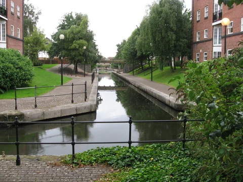
Erie Canal
Historic canal linking the Hudson River to Lake Erie.

via Wikipedia: Erie Canal · see source
The Erie Canal is a historic canal in upstate New York that runs east–west between the Hudson River and Lake Erie. Completed in 1825, the canal was the first navigable waterway connecting the Atlantic Ocean to the upper Great Lakes above Niagara Falls, vastly reducing the costs of transporting people and goods across the Appalachians. The Erie Canal accelerated the settlement of the Great Lakes region, the westward expansion of the United States, and the economic ascendancy of New York state.
- number_of_locks
- 35 (Erie Canal section of the Barge Canal)
Verified Timeline
Lore & Background
The construction of the Erie Canal was a landmark civil engineering achievement in the early history of the United States. When built, the 363-mile (584 km) canal was the second-longest in the world after the Grand Canal in China. Initially 40 feet (12 m) wide and 4 feet (1.2 m) deep, the canal was expanded several times, most notably from 1905 to 1918 when the "Barge Canal" was built and over half the original route was abandoned. The modern canal measures 351 miles (565 km) long, 120 feet (37 m) wide, and 12 feet (3.7 m) deep. It has 35 locks, including the Waterford Flight, the steepest locks in the United States. When leaving the canal, boats must also traverse the Black Rock Lock to reach Lake Erie or the Troy Federal Lock to reach the tidal Hudson. The overall elevation difference is about 565 feet (172 m). The canal saw quick success upon opening on October 26, 1825, with toll revenue covering the state's construction debt within the first year of operation. The westward connection gave New York City a strong advantage over all other US ports and brought major growth to canal cities such as Albany, Utica, Syracuse, Rochester, and Buffalo.
Reader's Guide
The Erie Canal was a transformative infrastructure project that reshaped the economic geography of the United States. By providing a cost-effective water route across the Appalachians, it slashed transport costs by about 95 percent, enabling the efficient movement of people and goods between the Atlantic coast and the Great Lakes region. This accelerated the settlement of the Great Lakes region and the westward expansion of the United States, while cementing New York City's dominance as a port and driving growth in cities along the canal. The canal's success demonstrated the power of state-funded public works and set a precedent for later infrastructure projects. Although commercial traffic declined in the 20th century due to railroads, trucking, and the St. Lawrence Seaway, the canal remains significant today. It is mainly used by recreational watercraft, connects three other canals in the New York State Canal System, and is part of the Great Loop for long-distance boaters. The Erie Canal has become a tourist attraction, with parks and museums dedicated to its history, and the New York State Canalway Trail offers a popular cycling path. In 2000, Congress designated the Erie Canalway National Heritage Corridor to protect and promote the system, ensuring its legacy endures.
Did You Know?
- The Erie Canal was the second-longest canal in the world when built, after the Grand Canal in China.
- Political opponents called the project 'Clinton's Folly' and 'Clinton's Big Ditch' after its lead supporter, New York Governor DeWitt Clinton.
- Toll revenue covered the state's construction debt within the first year of operation after the canal opened on October 26, 1825.
- The Waterford Flight contains the steepest locks in the United States.
- The canal's last regularly scheduled hauler, the Day Peckinpaugh, ended service in 1994.
Engineering a Staircase Through Ohio's Terrain
The Miami and Erie Canal was no simple ditch. To manage these dramatic elevation changes, engineers designed a staircase of 103 canal locks, three guard locks, and 19 aqueducts. Water supply was a persistent challenge: the state constructed man-made reservoirs including Grand Lake St. The canal itself measured 40 feet wide at water level with a depth of four feet, flanked by a ten-foot towpath and slopes graded at 4.5 feet horizontal to four feet perpendicular. Construction spanned two decades, from 1825 to 1845, and cost the state government eight million dollars—roughly 276 million in 2025 terms.
A Political and Economic Necessity
When Ohio achieved statehood in 1803, its interior was largely cut off from outside markets. The Appalachian Mountains stood between the state and the Atlantic Coast, making imported goods expensive and limiting farmers' and merchants' ability to sell beyond state borders. High shipping costs stifled both trade and population growth, particularly in regions far from natural waterways. The solution many envisioned was a canal system, a concept endorsed even by George Washington. Congress passed canal bills in 1817, 1822, and 1830, only to see each vetoed. With New York's Erie Canal proving the model in 1825, Ohio's legislature finally passed authorizing legislation on February 4, 1825. The state funded construction largely through land sales near the canal route, and the resulting network connected the interior to New York City via Lake Erie, the Erie Canal, and the Hudson River.
Life on the Towpath and in the Communities Alongside
For two decades after its completion, the Miami and Erie Canal hummed with the steady rhythm of animal-drawn commerce. Boats measuring up to eighty feet in length were towed along a prepared towpath by teams of mules, horses, or oxen, crawling at a pace of four to five miles per hour. The towpath was a mandatory ten-foot-wide strip running alongside the canal's bank, and the entire waterway was engineered to accommodate vessels up to ninety feet long and fourteen feet wide. The canal also shaped community identity. These extensions brought the canal's commerce closer to interior communities that had previously depended on poor roads for trade.
Railroads, Floods, and Fading Memory
The canal's commercial life was shorter than its builders had hoped. Railroads began appearing in the region in the 1850s, offering faster and larger-capacity transport for both passengers and freight. Ohio's canal system also faced structural disadvantages compared to New York's: where the Erie Canal spanned 363 miles with a 700-foot elevation change, Ohio's two canals combined for 557 miles and a 2,096-foot climb, spreading trade too thinly across a longer, costlier network. The state's population and economic development at the time were also lower than New York's, reducing the volume of traffic available to justify operations. The final blow came in 1913, when a historic flood in Ohio severely damaged the waterway, and it was permanently abandoned for commercial use. Today, only a small fraction of the original canal survives, along with remnants of its towpath and locks, a quiet reminder of the engineering ambition and economic hopes that once animated the Ohio landscape.
Frequently Asked Questions
What is the Erie Canal?
It is a historic waterway in upstate New York that runs east to west, linking the Hudson River with Lake Erie. Today it is recognized as a foundational piece of American canal history.
When was the Erie Canal completed and what made it a first?
The canal was finished in 1825 as the first navigable route connecting the Atlantic Ocean to Lake Erie. By sidestepping Niagara Falls, it opened a continuous water passage that had not existed before.
How many locks does the Erie Canal have?
The Erie Canal section of the Barge Canal features 35 locks.
Why is the Erie Canal considered so important?
It slashed the cost of moving goods and people, which in turn accelerated settlement of the western territories. New York's commercial power grew enormously as a direct result, reshaping the nation's economic center of gravity.
What is the Erie Canal's status today?
It survives as a historic waterway within the larger Barge Canal system, preserving its legacy as the project that first stitched the East Coast to the Great Lakes.
More in Canals And Waterways 1-24
Elsewhere in the Canals And Waterways universe
Spotted an error? Know more?
This is a living reference — every entry is fact-audited, and reader corrections feed straight into our audit queue. Suggest an edit · See this site's audit record